

The following SMART 100 profile and the information it contains is a duplication of content submitted by the applicant during the entry process. As a function of entry, applicants were required to declare that all details are factually correct, do not infringe on another’s intellectual property and are not unlawful, threatening, defamatory, invasive of privacy, obscene, or otherwise objectionable. Some profiles have been edited for reasons of space and clarity. More about the SMART 100.
This innovation initially came to life when…
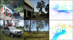
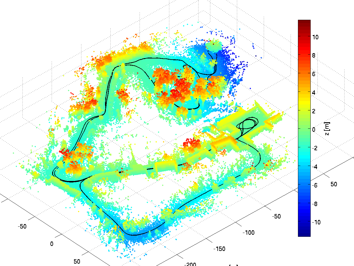
A research team custom-built a 3D laser range sensor for mapping the environment from a moving vehicle. The research group had previous experience with 2D laser mapping and positioning, and when extending their work to three dimensions was required to overcome a number of challenges. Most significantly, acquiring a full 3D scan takes much longer than a 2D scan, and therefore the data is susceptible to distortions due to the vehicle’s motion. A software solution was developed and tested with the sensor mounted on a Bobcat driven around our research facility.
WHAT & HOW
The purpose of this innovation is to…
Facilitate the creation of three-dimensional maps from a moving vehicle while simultaneously computing the precise motion of that vehicle using solely a laser range scanner, without requiring any additional navigational aids.
It does this by…
Using range measurements captured by the laser scanner to estimate how the vehicle is moving relative to the environment. Measurements from nearby points are used to reconstruct partial surfaces, and surfaces seen at different times are used to estimate the vehicle motion during that time. Knowledge of vehicle motion limitations is used to smooth the estimates.
PURPOSE & BENEFITS
This innovation improves on what came before because…
It enables the vehicle to move continuously while scanning the environment. Consequently, mapping does not interfere with other tasks being performed, so there are no interruptions to operations. The solution only requires a single sensor and the system is hence cheaper, easier to install, maintain, and calibrate compared with existing systems.
Its various benefits to the customer/end-user include…
The ability to provide situational awareness (including graphical interfaces for visualisation and analysis) which improves health and safety in addition to enabling measurement of material volumes, and automation of mobile equipment.
COMPETITIVE LANDSCAPE
In the past, this problem was solved by…
Requiring vehicles to frequently stop to statically scan the environment, or by the use of additional sensors such as GPS and inertial measurement systems (INS) to estimate vehicle motion. Stopping to scan is time-intensive, slowing down operations. GPS is not available everywhere and quality INS are expensive and often export-restricted.
Its predecessors/competitors include…
Larger and more expensive systems that still require data correction when the vehicle is moving, range cameras, and stereo camera systems. Other drawbacks include range limitations, sensor noise, or a strong dependence on lighting conditions.
TARGET MARKET
It is made for…
The concurrent mapping and localisation of a vehicle, especially in regions which lack continuous GPS service and where other methods of navigation are uneconomical to implement. The target markets addressable by this technology span indoor structured environments (such as offices and stadiums) through to outdoor unstructured environments (such as mining and industrial sites). The solutions the technology provides is specific to the particular sector and may include updating floor plans for health and safety audits through to real-time terrain mapping of an open cut coal mine, making it a true global technical solution.
DISTRIBUTION STRATEGY
It is available for sale through…
CSIRO and its licencees. CSIRO is currently identifying a number of key partners across a broad spectrum of fields, such as mining, agriculture, and infrastructure to deliver the solution to the market.
Our marketing strategy is to…
Partner with global providers of navigation technologies and vehicle manufacturers. Due to CSIRO’s prior success with OEMs in the mining sector, our initial focus will be to address their needs. However, as this technology has a broader base, our strategy will extend to find partners in allied fields such as agriculture, infrastructure monitoring, and security.
SUPPORTING IMAGES AND/OR VIDEO

SHOW YOUR SUPPORT FOR THIS INNOVATION
While the judging is now officially over, you can still show your support for this innovation in one of the following three ways:
- Hit the VOTE UP button: Top left of each page (Not available for IE users)
- Trigger a Reaction: Re-Tweet, Like on Facebook, etc.
- Leave a Comment: Share the love!
To check out the Anthill SMART 100 Readers’ Choice winner for 2010, click here.

")